domingo, 20 de dezembro de 2009

Ancient Egyptian World Map - Oldest world map, from Ancient Egypt, shows the Earth seen from outer space. Connection between Mars and planet Earth.

Written by Leandro for the website Hidden History - The former dwellers of the Earth
(http://hiddenhistory.50webs.com/oldest-world-map.html)
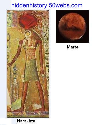
Harakhte, one of the most important deities of Ancient Egypt, is often depicted with a red globe on his head, I believe it to be Planet Mars, that is, as we have analyzed before, where they collected part of the material resources to build the temples here on Earth.

Harakhte and Mars.


Harakhte! Great god, lord of heaven, lord of Earth, who cometh forth from the horizon. He illuminateth the Two Lands, the sun of darkness, as the great one, as Re.

Horemheb
J. H. Breasted, Ancient Records of Egypt, Part Three, § 3


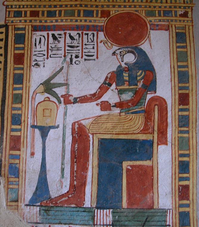
Harakhte on his throne in the heavens.


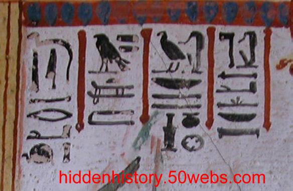
Let's take a look at the inscriptions...


hieroglyphs.

There is a figure that, according to our modern historical comprehension, couldn't be among these hieroglyphs, the last one of the first row. It shows a serpent, and inside the serpent is a very familiar place, it shows the African Continent in the center, as it looked more than 5.000 years ago, part of Eurasia, and a small part of South America, as seen from space. They depicted planets inside snakes.

Notice the space between Africa and Europe (Mediterranean Ocean), and the two points where the continents connect (Spain and Saudi Arabia). On the far right it's possible to see even a small part of the Island of Madagascar, and a small portion of the Brazilian coastline on the base; besides, obviously, the Atlantic and Indic oceans:

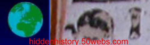
World map by the Ancient Egyptian civilization.


The precision of the contours and proportions of the continents is of a quality that has only recently been equalled.

The symbol beside the Earth represents map. Maybe it is one of the maps used by Piri Reis thousands of years later?

This world map by the ancient egyptian civilization can be the oldest map in the world, and therefore, the first map to show the Earth seen from space.

quarta-feira, 4 de novembro de 2009

Secrets of Easter Island - The discovery of an astonishing pattern to the craters completely overthrows the meteor impact theory.

Written by Leandro for the website Hidden History - The former dwellers of the Earth

Everyone knows the huge stone heads ('moai') of the fascinating Easter Island, located in an isolated region in the middle of the Pacific Ocean. What they don't know, is that the stones used for the construction of those stunning monuments were taken from round craters of more than 500 meters (1500 feet) in diameter carved in the center of Rano Raraku and Rano Kao mounts.

Exactly, those are mounts, there are none, and there have never been volcanoes on Easter Island.

Firstly, volcanic soil is sterile, because it doesn't contain the humus needed for the nutrition of the plants, nevertheless, the whole island has vegetation, even a forest, as the following satellite image shows:

Satellite view of Easter Island.


The fact is that there is not even a single piece of evidence that there has ever been volcanic activity on the island.

Moai on Easter Island.


Look at how desolate the scenery in areas formed by volcanic activity is:

Volcanoes Popocatepetl and Iztaccíhuatl, in Mexico.


In the picture above of the mexican volcanoes Popocatepetl and Iztaccíhuatl, we can see the deep and ample channels that formed on the soil, caused by the movement of the super heated mass that had flown during the eruption, elements that we don't have on Easter Island.

How could those volcanoes have arisen from the depths of the ocean and made an island? This question must surely baffle the geologists that made up that story about volcanoes. I won't get into details regarding the obvious stumbling blocks, about how such volcanos had to be active at the same time, releasing an amount of lava at an equivalent rate in order to have a certain stability of growth, until all this volume of mass would somehow accumulate, solidify and reach a level above the waters.

And if it really happened, it is likely that the volcanoes would be found in the highest spot, surrounded by all the condensed lava.

See the case for Mount Fuji, on Honshu island. The volcano is the highest spot in Japan, at an altitude of 3,7 km (12,388 ft):

Mount Fuji, Japan's highest mountain.


The Popocatepetl is the second highest peak in Mexico, at an altitude of 5,4 km (17,802 ft).

Strangely, the supposed volcanoes of Easter Island are on low parts.

Topographical map of Easter Island.


Analyzing the topography of the area, we can perceive that the central part of the island has the highest altitude. Cerro Terevaka, the highest spot, stands at 507 m (1500 feet) high, on the other hand, the highest 'volcano', Puakatike, stands more than 130 m (390 feet) below, how is this possible? Would have all the lava converged to a central point and flown upwards?

It is a good idea to explore the island through this website that displays satellite images:
http://www.wikimapia.org/#lat=-27.1203339&lon=-109.3105316&z=14&l=0&m=a&v=1

Now check out something extremely interesting, this one above is Wolfe Creek, one of the so called 'meteor impact crater', and is on the west side of Australia. Beneath is Rano Raraku 'volcano', on Easter Island:


Comparison between the craters Wolfe Creek and Rano Raraku.

Both craters exhibit a triangular mark on the border and an internal concentration. One they say is the impact of a meteor, the other, due to it being on a small island, they say is a volcano. In fact, they are neither one thing nor the other.

Did you know that the material that the researchers claim to have found at the 'impact craters' and that could be of an external origin, like the Iridium, is actually found worldwide, underground, as a remnant of an era when the planet Earth passed through a cloud of dust? The melted rocks, are actually igneous formations, solidified magma in the subsoil. These 2 evidences are consistent with a process of extraction of the soil revealing inferior layers.

Another intriguing factor, is that in the Gulf of Mexico, next to the place of the supposed impact which theoretically caused the extinction of the dinosaurs, the Iridium is found at low concentrations, now far away, in Denmark, higher concentrations are found, which indicates that this material is not related to a meteor impact.

There are more very relevant clues that there really was no impact, such as the geological distance between the formation of the crater and the layer where the material was found, with intermediaries of organic origin. This means that after the formation of the crater there was no tragedy, organisms continued to inhabit the place and only much later appeared the layer of cosmic dust.

Site of extraction of the soil on Mars:

Crater of extraction of the soil, on Mars.

The crater in the Arizona desert, United States:

Crater of extraction of the soil in the desert of Arizona.

Rano Kao:

Rano Kao, extraction of the soil on Easter Island.

Another martian crater:

Extraction of the soil. Characteristic mark on the rim of the quarry crater on Mars.


Any resemblance is not a mere coincidence.

Secrets of Mars - Evidences of civilizations and ruins on Mars. The ultimate proof that Mars has sustained intelligent life.

Written by Leandro for the website Hidden History - The former dwellers of the Earth
(http://hiddenhistory.50webs.com/buildings-on-mars.html)

Here you can see an intriguing landscape of the Cydonia Mensae region, on Mars. It is a perfect geometric structure, in high relief and of enormous proportions. This pentagon exhibits round craters, that the astronomers mistakenly consider to be 'meteor impact holes', on exactly three of its joints, forming a triangle. On the inside there's a visible pyramidal structure.
Right beneath we find a perfect spherical crater, maybe caused by a perfect round asteroid, that maybe hit the ground on a perfect vertical line, and disappeared without a trace afterwards.

Pentagon with a pyramid inside, on Mars.


Notice the symmetry of this crater, the opposing sides of its border show contours of impressive resemblance, like an apple. See the internal leveling of the crater.

Leveled and symmetrical crater, on Mars.


This crater shows signs of movement of material, look at the external line leading to the pit.

Crater with a trail, on Mars.


Unexplainable symmetric perfection. Notice the details of the east-west and north-south relation.


Crater with two gaps on its rim, on Mars.


The situation starts to become funny when we compare some of the craters with unidentified objects photographed and filmed by NASA itself. Below, two craters found on the surface of Mars, and on the right, an object photographed in 1996 in the event that became known as 'NASA tether incident'.

Comparison between the craters and UFO filmed during the STS-75 mission.

Columbia shuttle had launched a small satellite with a 19 km (12 mi) long tether that broke instants after reaching the space. Suddenly, countless luminous objects started to encircle the tether. Watch the filming of the event here:

http://www.youtube.com/watch?v=As-wYmFYb3I

and here:

http://br.video.yahoo.com/watch/4753539/126958757

An unexpected overload caused the tether to break, and both satellite and tether began to be inspected by objects that seem to appear from the invisible.